Sunday, May 31, 2015

May 28 - Derry to Galway

Today we left Derry and headed to Galway with several stops along the way.

Our first stop was Beleek Pottery in Beleek, Northern Ireland which was right on the border between Northern Ireland and Ireland.  John Bloomfield inherited his father's estate in 1849 and set about looking for employment for the tenants on the estate who had been affected by the Potato Famine.  A geological survey indicated that the area was rich in the materials needed to make fine pottery so along with two partners, he started the pottery business in 1865.  It is now famous for is fine ceramics.  We took a tour through the factory.  This photo shows pieces after the molding before firing.


Here our guide shows us the molds they use which are only used for a short time before they have to be retired.  Apparently they have a warehouse with these old molds.


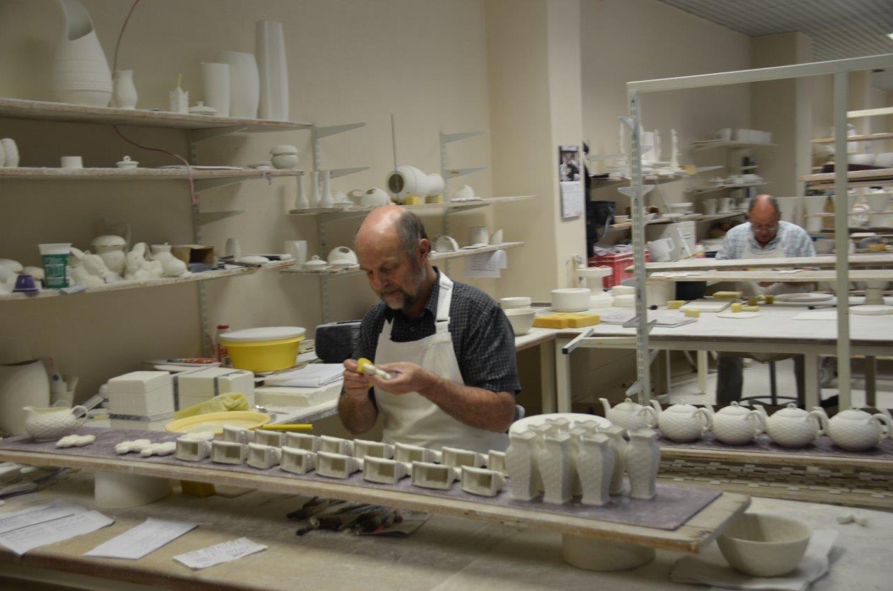
This gentlemen is cleaning the flash off the freshly mold part prior to firing.


This is a ceramic woven basket in the process of being made.  They take ceramic material that has been extruded into thin strands and weave the basket over a mold.


Here is a brief video of a guy making flowers, one petal at a time.


And here are his flowers prior to firing.


Here is the kiln they use.


After the initial firing the piece is plain white.  Here a woman is painting the colors on to a ceramic basket.


Some of the pieces are pretty amazing both as to design and price.  This large piece sells of €75,000.


Here is a more reasonably priced piece only a few hundred Euros.


Our next stop was very brief as we visited this church of St. Columba in Drumcliffe..


Its claim to fame is that W. B. Yeats is buried here.


Our next stop was the town of Knock.  It is famous because in 1879 The Blessed Virgin Mary, St. Joseph, and John the Evangelist appeared to a small group of 15 people.  Below is an artist representation of what they saw.


This basilica was built for the visit of Pope John Paul II to the shrine in 1979.


It is a very popular pilgrimage site.  While we were there this group was processing the grounds while reciting the rosary.  More about the site can be found at:  www.knockshrine.ie.


We arrived in Galway and for dinner this evening we drove to this medieval castle, Dunguaire.  It was built in 1520 by the O'Hynes clan.  This type of castle is known as a tower house and a large number of them were built throughout Ireland by minor clans.  This particular one has been restored and during the day it is open for tourists but in the evening they have banquets and that was why we were here.


On entering the castle we were serenaded by this lady playing the harp.


Here is some of our group at the banquet tables.


After dinner we were entertained by this small ensemble.


Also in the area were thatched cottages like this one that could be rented.


That was it for today.  Tomorrow we tour the area around Galway and visit the old city center.

Friday, May 29, 2015

May 27 - Derry and Inishowen Peninsula

This morning we are going on a tour of the Inishowen Peninsula in County Donegal.  This is in Ireland not Northern Ireland but since Derry is right on the border, we are in County Donegal in 5 minutes.  The Inishowen Peninsula is the largest and most northern in Ireland and it is very rugged. and contains the most northern point in Ireland, Malin Head.

Our first stop on the peninsula is Grianan Aileach which is the ancient ring fort that was the royal seat of the Kingdom of Aileach.  Here is a photo of that fort as we approach it.


Aileach was ruled by the Uí Néill (O Neill) clan which was the clan that controlled most of northern Ireland before the Normans arrived and was probably the most powerful clan in Ireland.  The clan leaders were descendants of  Niall Noigiallach, also know as Niall of the Nine Hostages, who died in 405 AD.  Multiple members of this clan ruled as High King of Ireland over the years before the Normans conquered Ireland.  This fort was built in about 6th or 7th century but the site goes back to neolithic times and is believed to have been use as early as 3,000 BC,  Here is an inside view of the fort from ground level.


The fort sits on a hill 800 feet high, it is 78 feet in diameter on the inside, the walls are 15 feet thick and 16 feet high.  I climbed the stairs to get a better view.  Here is a photo I took.


It was really cold and the wind was blowing hard so we were all freezing out butts off.  Pat is in the center of the photo in a light colored rain coat with her hood up and her hands in her pockets trying to keep warm.  This fort is strategically located at the entrance to the peninsula which is bounded on the
western side by Lough Swilly and on the eastern side by Lough Foyle.  In these photos you can see two branches of Lough Swilly with the island of Inch between them.


Inside the walls of the fort there are passages but they were closed off and you would have to be pretty small and agile to make your way through them.  Here is a photo of the entrance to those passages.


We then started our trip north up the peninsula.  We passed this small church with this bell which was supposedly recovered from the wreck of the Spanish Armada off the coast in 1588.


We reached Malin Head and you can get an idea of how desolate and wild this country is in the next few photos.


There are farmers living here raising sheep.


This tower was built by the British in 1805 during the Napoleonic wars.  It was later used as a Marconi radio site and the Titanic used it to test their radios as it headed out on it fateful voyage.


Some of the very rugged off shore islands.


We then headed back to Derry and drove through the Catholic side of town.  This is where the first incidents of the Troubles happened and there are a number of murals about the Troubles as in these photos.


The Catholics in Derry refer to their area of town as Free Derry.


This mural is a memorial to a young school girl who was killed by British troops in what became know as Bloody Sunday.


Derry is a walled city and still has its medieval walls and gates.  We have just entered this gate on the northern edge of the old city.


This church, in the old part of Derry, is St. Eugene's Cathedral.  Ever since Henry VIII, Catholic churches had not been allowed.  When the Roman Catholic Relief Act of 1829 was passed, Catholics were legally allowed to build churches and this cathedral was built in the 1840s.


This building is the First Derry Presbyterian Church.  This building was erected in 1780.  The British were Anglican and the native Irish were Roman Catholic but the Scots that the British brought in to work the lands that the British confiscated from the Irish were Presbyterian and this was their church.


Here we are walking the city walls.


We went about half way down the walls and then crossed the city to come out at the gate next to the Guild Hall.  Here is that gate.


Here is the outside of the walls facing the river.  At the time these walls were built the river flowed next to them and the cannon on the walls were used to defend the city against ships in the river.


Here is the side of the Guild Hall facing the city walls.


And here is the side facing the river.


The Guild Hall was built in 1890 and was accidentally burned down and rebuilt in the early 20th century and then was damaged in the 1970s by IRA bombs.  Now it is fully restored and has a museum on the first floor and the city council meeting room and ballroom on the second floor.  Here is the organ in the ballroom.


Some of the stained glass windows in the ballroom.


The museum had an exhibit about the Ulster Plantation that the British tried to establish in this area. This was an attempt under King James I of England in 1609  to force the Irish out of the area and repopulate it with Protestant British and Scot settlers.  The requirement was that all colonists living on the plantation had to be Protestants so the Irish either had to convert or leave.  For the most part it was a failure as the Irish for the most part never left the area or converted.

Tomorrow we leave Derry and head to Galway with some stops along the way.


Thursday, May 28, 2015

May 26 - Belfast to Derry

This morning we packed up our suitcases for our trip to Londonderry/Derry with some stops along the way.  The original name of the town was Derry and that's what the Irish nationalists still call it.  It was given the name Londonderry by the English to acknowledge its importance and that is what the Unionists call it.

However, before we left Belfast we visited the Titanic Museum.  The Titanic was built in Belfast, as during the late 19th and early 20th centuries Belfast was a major shipbuilding center.


  Here is Pat just about to enter the museum.


At the time of it's launch in 1912 the Titanic was the largest and most elegant steamship afloat.  It was the second of the three Olympic class steamships built by Harland & Wolff between 1908 and 1914.  Olympic was the first, then Titanic and finally Britannic.  Titanic sank during it's maiden voyage in 1912 after hitting an iceberg,  Britannic sank in 1916 after hitting a mine laid by the Germans during WW 1.  Olympic continued to serve until retired in 1934.


One of the interesting things in the museum was a brief history of Belfast.  For a period of time it was known as the Linen Capital of the world.  That was interesting to us because, from the records we have been able to find, the Moonans in the Collon area were flax growers and flax is the raw material from which linen is made


We rode in a car suspended from an overhead track that took us through a mock up of the shipyard as it was during the building of the Titanic.


At the time of her sinking, Titanic was the largest ship afloat.  She was 883 feet long and displaced 52,310 tons.  To give you an idea of the size, they had this photo of the boilers used in Titanic with some people in the background to give you an idea of their size.


There were 2,224 passengers and crew aboard when she sunk.  Only 710 were saved with 1,514 losing their lives.  They had a lot of information on both survivors and those lost in the wreck.  Here is an example of three who were lost.


There were many attempts to find the Titanic with some wild hopes that the ship could be raised.The ship was finally located by Robert Ballard in 1985.  They found her at 12,415 feet and split in two and about 13 miles away from where she had been reported at the time of the sinking.  They showed a video that had been done by Robert Ballard in 2004.  Here is a still from that video.


This one shows the remains of the Captain's bathroom complete with tub.


After leaving Belfast we headed north.  Lots of sheep.


Here is some leg of lamb on the hoof.


Lots of offshore islands.


This one is close enough that the locals have built a rope bridge so you can cross over to it.


Here are some folks crossing that rope bridge.  Pat and I took one look and decided that wasn't for us.


The locals use this island for salmon fishing and you can see their nets and boat in this photo.


This island is a wildlife refuge.


There were a lot of sandy beaches but it was a little too cold to consider visiting them.


Our next stop was the Giant's Causeway.  This in an area on the north coast where basalt columns have been exposed.  This is the same type structure as formed the Devil's Tower in Wyoming (as shown in the movie "Close Encounters of the Third Kind").  Here some folks are exploring this very rugged coastline.


Here you can see the hexagonal basalt columns that have been exposed due to erosion.  These columns had originally been formed by volcanic activity 50 - 60 million years ago but were buried and only recently (50 - 60,000 years ago) exposed by erosion.


The ancient Gaelic legend is that these are the remains of a causeway that a giant (Finn MacCool) had built so he could get to Scotland to fight another giant that lived there (Benandonner).  There is a matching set of columns in Scotland at Fingal's Cave that are part of the same lava flow.  Here you can see more of the columns.


And here.


And here they have cut a path thru them.


And more of them on the next section.


As you can see people love too climb over them.


Here is Pat freezing as it was very cold and windy.


As we continued on our way to Derry we passed this ruin of a castle.


And more sandy, empty beaches.


There was also a number of golf courses, this one I believe is the Royal Portrush Golf Club.  A very windy and cold day to be out on a golf course but boy were the green and fairways lush and green.


We arrived in Derry and after checking into our hotel we went on a quick tour.  This is the grounds of the Ebrington British Army Barracks on the east side of the River Foyle.  They were built in 1841 and were used until 2003.  They are now owned by the city and are being converted for public use.

During the Troubles they were a key point used by the British.


During WW 2, Derry was a key port used in the Battle of the Atlantic and the Ebrington Barracks were used by the US troops and the British Royal Navy and others fighting the German U-Boats.  At the end of the war about 65 U-Boats surrendered in Derry.  This memorial was built to remember all of the allied sailors that were lost during the Battle of the Atlantic.


Here is the Guild Hall in Derry.  It was built in 1890 and we willl be visiting it tomorrow.


Here is a photo of the pedestrian Peace Bridge that was built across the River Foyle to symbolize the end of the Troubles.


Tomorrow we will tour the Inishowen Peninsula which is the most northern point in Ireland and then tour the city.